


cap Morgiou

gdela
User
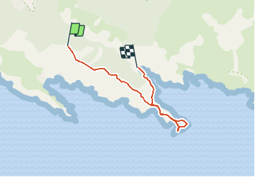

Length
5.1 km

Max alt
255 m

Uphill gradient
133 m
Km-Effort
7.6 km

Min alt
2 m

Downhill gradient
364 m
Boucle
No
Creation date :
2020-10-01 12:38:06.023
Updated on :
2020-10-01 13:05:01.424
--
Difficulty : Medium

FREE GPS app for hiking
 SityTrail
IGN / Geographical institutes
SityTrail Plus
The world is yours!
About
Trail On foot of 5.1 km to be discovered at Provence-Alpes-Côte d'Azur, Bouches-du-Rhône, Marseille. This trail is proposed by gdela.
Description
a partir du GR 51-98, rtour par village de Morgiou
Positioning
Country:
France
Region :
Provence-Alpes-Côte d'Azur
Department/Province :
Bouches-du-Rhône
Municipality :
Marseille
Location:
9th Arrondissement
Start:(Dec)
Start:(UTM)
697008 ; 4787762 (31T) N.
Comments