


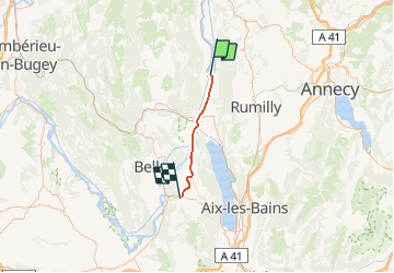
De Motz à Yenne

DaVinci
User

Length
27 km

Max alt
256 m

Uphill gradient
143 m
Km-Effort
29 km

Min alt
218 m

Downhill gradient
167 m
Boucle
No
Creation date :
2020-10-01 16:43:35.668
Updated on :
2020-10-01 16:44:30.951
4h30
Difficulty : Medium

FREE GPS app for hiking
 SityTrail
IGN / Geographical institutes
SityTrail Plus
The world is yours!
About
Trail Canoe - kayak of 27 km to be discovered at Auvergne-Rhône-Alpes, Savoy, Motz. This trail is proposed by DaVinci.
Positioning
Country:
France
Region :
Auvergne-Rhône-Alpes
Department/Province :
Savoy
Municipality :
Motz
Location:
Unknown
Start:(Dec)
Start:(UTM)
719340 ; 5089447 (31T) N.
Comments