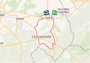
Trail Walking Étalle - Vance Adeps 2020 - Photo

Vance Adeps 2020

© OpenStreetMap contributors
Length
Length
11 km
Max alt
Max alt
369 m
Uphill gradient
Uphill gradient
108 m
Km-Effort
Km-Effort  
12.4 km
Min alt
Min alt
333 m
Downhill gradient
Downhill gradient
106 m
Boucle
Boucle
Yes
Creation date :
2020-10-03 07:49:34.937
Updated on :
2020-10-03 13:25:42.654

(0 Reviews)

Walking
Walking
2h23
Difficulty : Easy

Scan this QR Code to open this trail in the SityTrail application

FREE GPS app for hiking

Logo SityTrail SityTrail

IGN / Geographical institutes

Download SityTrail from the App Store Download SityTrail from Google Play

Logo SityTrail SityTrail Plus

The world is yours!

Download SityTrail from the App Store Download SityTrail from Google Play Download SityTrail on Huawei AppGallery

About

Trail Walking of 11 km to be discovered at Wallonia, Luxembourg, Étalle. This trail is proposed by fra_depoorter.

Description

Merveilleuse randonnée, essentiellement sous bois sans difficulté. Un peu de tarmac au départ et en fin de parcours; court passage boueux, débardage récent.
Traversée de Chantemelle très plaisante. A ne pas manquer. Merci aux organisateurs dévoués.

Elevation profile

Positioning

Country:
Belgium
Region :
Wallonia
Department/Province :
Luxembourg
Municipality :
Étalle
Location:
Vance
Start:(UTM)
692563 ; 5505338 (31U) N.


Close
My subscriptions