


randonnée chemin du vigneron à Celles sur Ource

MoiClaude
User
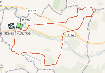

Length
11.1 km

Max alt
280 m

Uphill gradient
257 m
Km-Effort
14.5 km

Min alt
156 m

Downhill gradient
253 m
Boucle
Yes
Creation date :
2020-10-03 12:07:39.827
Updated on :
2020-10-03 15:12:40.741
2h15
Difficulty : Very easy

FREE GPS app for hiking
 SityTrail
IGN / Geographical institutes
SityTrail Plus
The world is yours!
About
Trail Walking of 11.1 km to be discovered at Grand Est, Aube, Celles-sur-Ource. This trail is proposed by MoiClaude.
Description
Rendonnée du vigneron
Positioning
Country:
France
Region :
Grand Est
Department/Province :
Aube
Municipality :
Celles-sur-Ource
Location:
Unknown
Start:(Dec)
Start:(UTM)
604408 ; 5325773 (31U) N.
Comments
Superbe randonnée, des vues à 180,vraiment top, ainsi que notre guide.