


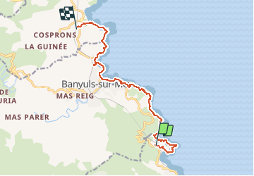
Cerbere Banyuls le chemin des douaniers

jeanic63
User

Length
13 km

Max alt
114 m

Uphill gradient
328 m
Km-Effort
17.5 km

Min alt
0 m

Downhill gradient
370 m
Boucle
No
Creation date :
2020-10-03 16:33:58.989
Updated on :
2020-10-03 16:38:11.604
--
Difficulty : Difficult

FREE GPS app for hiking
 SityTrail
IGN / Geographical institutes
SityTrail Plus
The world is yours!
About
Trail On foot of 13 km to be discovered at Occitania, Pyrénées-Orientales, Cerbère. This trail is proposed by jeanic63.
Description
Départ paking de paulille port Vendres
Positioning
Country:
France
Region :
Occitania
Department/Province :
Pyrénées-Orientales
Municipality :
Cerbère
Location:
Unknown
Start:(Dec)
Start:(UTM)
512883 ; 4700523 (31T) N.
Comments