


2020-10-04_11h23m10_gpx-trace

Gegetop
User
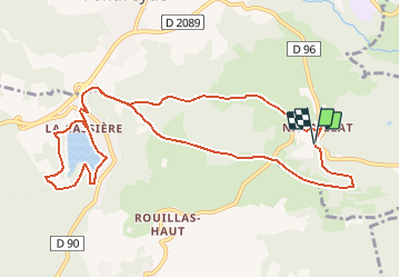

Length
12 km

Max alt
1036 m

Uphill gradient
371 m
Km-Effort
16.9 km

Min alt
863 m

Downhill gradient
374 m
Boucle
Yes
Creation date :
2020-10-04 09:23:11.075
Updated on :
2020-10-04 09:40:46.991
3h00
Difficulty : Medium

FREE GPS app for hiking
 SityTrail
IGN / Geographical institutes
SityTrail Plus
The world is yours!
About
Trail Nordic walking of 12 km to be discovered at Auvergne-Rhône-Alpes, Puy-de-Dôme, Saint-Genès-Champanelle. This trail is proposed by Gegetop.
Photos


Positioning
Country:
France
Region :
Auvergne-Rhône-Alpes
Department/Province :
Puy-de-Dôme
Municipality :
Saint-Genès-Champanelle
Location:
Unknown
Start:(Dec)
Start:(UTM)
502589 ; 5059458 (31T) N.
Comments