


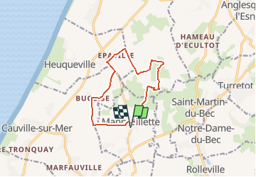
Mannevillette

Laurent53
User

Length
10.6 km

Max alt
103 m

Uphill gradient
120 m
Km-Effort
12.2 km

Min alt
61 m

Downhill gradient
120 m
Boucle
Yes
Creation date :
2020-10-04 13:56:20.867
Updated on :
2020-10-04 13:58:01.834
--
Difficulty : Easy

FREE GPS app for hiking
 SityTrail
IGN / Geographical institutes
SityTrail Plus
The world is yours!
About
Trail On foot of 10.6 km to be discovered at Normandy, Seine-Maritime, Mannevillette. This trail is proposed by Laurent53.
Positioning
Country:
France
Region :
Normandy
Department/Province :
Seine-Maritime
Municipality :
Mannevillette
Location:
Unknown
Start:(Dec)
Start:(UTM)
295964 ; 5497484 (31U) N.
Comments