forezan

papou73
User
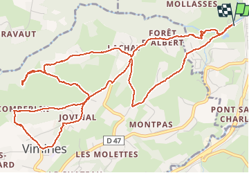

Length
8.2 km

Max alt
552 m

Uphill gradient
301 m
Km-Effort
12.2 km

Min alt
305 m

Downhill gradient
300 m
Boucle
Yes
Creation date :
2020-10-05 11:38:26.638
Updated on :
2020-10-05 14:27:32.162
2h48
Difficulty : Very easy

FREE GPS app for hiking
 SityTrail
IGN / Geographical institutes
SityTrail Plus
The world is yours!
About
Trail Walking of 8.2 km to be discovered at Auvergne-Rhône-Alpes, Savoy, Cognin. This trail is proposed by papou73.
Positioning
Country:
France
Region :
Auvergne-Rhône-Alpes
Department/Province :
Savoy
Municipality :
Cognin
Location:
Unknown
Start:(Dec)
Start:(UTM)
725489 ; 5048931 (31T) N.
Comments