Trail Walking Chiroubles - Chiroubles (14 km - D. 555 m) - Photo

Chiroubles (14 km - D. 555 m)

© OpenStreetMap contributors
Length
Length
13.9 km
Max alt
Max alt
741 m
Uphill gradient
Uphill gradient
555 m
Km-Effort
Km-Effort  
21 km
Min alt
Min alt
310 m
Downhill gradient
Downhill gradient
555 m
Boucle
Boucle
Yes
Creation date :
2020-10-08 07:42:56.0
Updated on :
2020-10-09 16:50:00.187

(1 Reviews)

Walking
Walking
5h18
Difficulty : Easy

Scan this QR Code to open this trail in the SityTrail application

FREE GPS app for hiking

Logo SityTrail SityTrail

IGN / Geographical institutes

Download SityTrail from the App Store Download SityTrail from Google Play

Logo SityTrail SityTrail World

The world is yours!

Download SityTrail from the App Store Download SityTrail from Google Play Download SityTrail on Huawei AppGallery

About

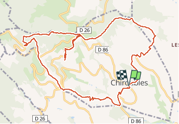
Trail Walking of 13.9 km to be discovered at Auvergne-Rhône-Alpes, Rhône, Chiroubles. This trail is proposed by Thomasdanielle.

Description

D/A Parking de la poste (Attention peu de place)
Très belle randonnée, très variée

Elevation profile

Positioning

Country:
France
Region :
Auvergne-Rhône-Alpes
Department/Province :
Rhône
Municipality :
Chiroubles
Location:
Unknown
Start:(UTM)
628499 ; 5115421 (31T) N.

Comments

Please log in to post a review or rate the element


Trails nearby

Trail Mountain bike Lantignié - 19e Rando des Primeurs - Photo
Mountain bike
tracegps

Mountain bike

Difficult
(1)
Lantignié, Auvergne-Rhône-Alpes, Rhône, France
30 km | 45 km-effort
3h 0min
Yes
Trail Walking Vauxrenard - vauxrenard - Photo
Walking
Zeugma13

Walking

Difficult
(1)
Vauxrenard, Auvergne-Rhône-Alpes, Rhône, France
21 km | 31 km-effort
5h 7min
Yes
Trail Walking Vauxrenard - Itinérant Beaujolais rouge étape 6 Foretal - Macon gare TGV - Photo
Walking
chessyca

Walking

Very difficult
Vauxrenard, Auvergne-Rhône-Alpes, Rhône, France
23 km | 28 km-effort
6h 26min
No
Trail Walking Chiroubles - Itinérant Beaujolais rouge étape 5 Chiroubles- Foretal - Photo
Walking
chessyca

Walking

Medium
Chiroubles, Auvergne-Rhône-Alpes, Rhône, France
23 km | 32 km-effort
5h 44min
No
Trail Walking Chiroubles - 2023-05-26_00h30m21_28127-15675317-2 (2) - Photo
Walking
daniellebou

Walking

Very difficult
(1)
Chiroubles, Auvergne-Rhône-Alpes, Rhône, France
16.9 km | 26 km-effort
5h 49min
Yes
Trail On foot Régnié-Durette - 2022-09-01_17h24m13_e3IWHtaTFWwfACzh8d3-Xw - Photo
On foot
Jean-Marc C

On foot

Medium
Régnié-Durette, Auvergne-Rhône-Alpes, Rhône, France
18.1 km | 25 km-effort
5h 40min
Yes
Trail Walking Fleurie - Fleurie (Rhône) 17 km - D. 498 m - Photo
Walking
Thomasdanielle

Walking

Medium
Fleurie, Auvergne-Rhône-Alpes, Rhône, France
16.7 km | 23 km-effort
5h 25min
Yes
Trail Walking Fleurie - les vignes de Fleurie - Photo
Walking
reneperrin

Walking

Easy
Fleurie, Auvergne-Rhône-Alpes, Rhône, France
8.1 km | 10.8 km-effort
2h 1min
Yes
Trail Walking Chiroubles - Fût d’Avenas  (13 km - D. 455 m) - Photo
Walking
Thomasdanielle

Walking

Medium
(1)
Chiroubles, Auvergne-Rhône-Alpes, Rhône, France
13 km | 19.1 km-effort
4h 21min
Yes


Close
My subscriptions