


savigny villcheneve courzieu

terrano
User
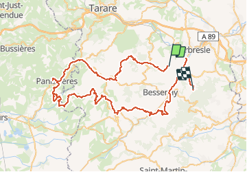

Length
89 km

Max alt
812 m

Uphill gradient
2580 m
Km-Effort
123 km

Min alt
232 m

Downhill gradient
2469 m
Boucle
No
Creation date :
2020-08-26 13:10:42.374
Updated on :
2020-10-10 09:00:47.95
6h33
Difficulty : Very easy

FREE GPS app for hiking
 SityTrail
IGN / Geographical institutes
SityTrail Plus
The world is yours!
About
Trail Quad of 89 km to be discovered at Auvergne-Rhône-Alpes, Rhône, Savigny. This trail is proposed by terrano.
Positioning
Country:
France
Region :
Auvergne-Rhône-Alpes
Department/Province :
Rhône
Municipality :
Savigny
Location:
Unknown
Start:(Dec)
Start:(UTM)
622005 ; 5074390 (31T) N.
Comments
Quad août 2020