


viffort

bruno38
User
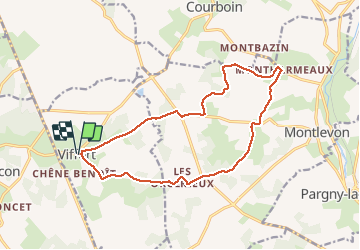

Length
14.8 km

Max alt
224 m

Uphill gradient
224 m
Km-Effort
17.8 km

Min alt
129 m

Downhill gradient
226 m
Boucle
Yes
Creation date :
2020-10-10 06:31:30.392
Updated on :
2020-10-10 09:32:44.353
2h56
Difficulty : Very easy

FREE GPS app for hiking
 SityTrail
IGN / Geographical institutes
SityTrail Plus
The world is yours!
About
Trail Walking of 14.8 km to be discovered at Hauts-de-France, Aisne, Viffort. This trail is proposed by bruno38.
Positioning
Country:
France
Region :
Hauts-de-France
Department/Province :
Aisne
Municipality :
Viffort
Location:
Unknown
Start:(Dec)
Start:(UTM)
533512 ; 5423192 (31U) N.
Comments