


2020-10-11_11h24m02_Etincelle-G2

papou73
User
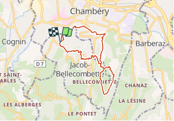

Length
7 km

Max alt
480 m

Uphill gradient
256 m
Km-Effort
10.4 km

Min alt
296 m

Downhill gradient
256 m
Boucle
Yes
Creation date :
2020-10-11 09:24:03.484
Updated on :
2020-10-11 09:25:49.468

FREE GPS app for hiking
 SityTrail
IGN / Geographical institutes
SityTrail Plus
The world is yours!
About
Trail of 7 km to be discovered at Auvergne-Rhône-Alpes, Savoy, Jacob-Bellecombette. This trail is proposed by papou73.
Positioning
Country:
France
Region :
Auvergne-Rhône-Alpes
Department/Province :
Savoy
Municipality :
Jacob-Bellecombette
Location:
Unknown
Start:(Dec)
Start:(UTM)
727115 ; 5049088 (31T) N.
Comments