


Orval-Margny 2020

fra_depoorter
User
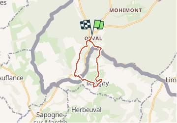

Length
7.8 km

Max alt
255 m

Uphill gradient
148 m
Km-Effort
9.8 km

Min alt
190 m

Downhill gradient
148 m
Boucle
Yes
Creation date :
2020-10-11 06:51:32.7
Updated on :
2020-10-11 14:37:24.707
1h48
Difficulty : Very easy

FREE GPS app for hiking
 SityTrail
IGN / Geographical institutes
SityTrail Plus
The world is yours!
About
Trail Walking of 7.8 km to be discovered at Wallonia, Luxembourg, Florenville. This trail is proposed by fra_depoorter.
Description
Belle randonnée, moitié en Belgique moitié en France, sur parcours varié (bois et campagne) et bien accessible.
Positioning
Country:
Belgium
Region :
Wallonia
Department/Province :
Luxembourg
Municipality :
Florenville
Location:
Villers-devant-Orval
Start:(Dec)
Start:(UTM)
669473 ; 5500895 (31U) N.
Comments