


les églises

any1950
User

Length
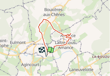
11.4 km

Max alt
392 m

Uphill gradient
255 m
Km-Effort
14.8 km

Min alt
214 m

Downhill gradient
256 m
Boucle
Yes
Creation date :
2020-10-11 12:26:02.026
Updated on :
2020-10-11 15:23:28.36
2h32
Difficulty : Very easy

FREE GPS app for hiking
 SityTrail
IGN / Geographical institutes
SityTrail Plus
The world is yours!
About
Trail Walking of 11.4 km to be discovered at Grand Est, Meurthe-et-Moselle, Dommartin-sous-Amance. This trail is proposed by any1950.
Positioning
Country:
France
Region :
Grand Est
Department/Province :
Meurthe-et-Moselle
Municipality :
Dommartin-sous-Amance
Location:
Unknown
Start:(Dec)
Start:(UTM)
298185 ; 5402024 (32U) N.
Comments