


Charnay

janussity
User
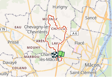

Length
12.1 km

Max alt
363 m

Uphill gradient
216 m
Km-Effort
15 km

Min alt
215 m

Downhill gradient
220 m
Boucle
No
Creation date :
2020-10-12 11:40:40.612
Updated on :
2020-10-12 14:45:27.944
2h46
Difficulty : Easy

FREE GPS app for hiking
 SityTrail
IGN / Geographical institutes
SityTrail Plus
The world is yours!
About
Trail Walking of 12.1 km to be discovered at Bourgogne-Franche-Comté, Saône-et-Loire, Charnay-lès-Mâcon. This trail is proposed by janussity.
Description
temps agréable 12 degrés
Positioning
Country:
France
Region :
Bourgogne-Franche-Comté
Department/Province :
Saône-et-Loire
Municipality :
Charnay-lès-Mâcon
Location:
Unknown
Start:(Dec)
Start:(UTM)
638111 ; 5129714 (31T) N.
Comments