


2020-10-12_18h34m05_Fenestro-G1

papou73
User
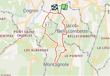

Length
6.6 km

Max alt
562 m

Uphill gradient
256 m
Km-Effort
10 km

Min alt
306 m

Downhill gradient
253 m
Boucle
Yes
Creation date :
2020-10-12 16:34:06.019
Updated on :
2020-10-12 16:35:53.094

FREE GPS app for hiking
 SityTrail
IGN / Geographical institutes
SityTrail Plus
The world is yours!
About
Trail of 6.6 km to be discovered at Auvergne-Rhône-Alpes, Savoy, Jacob-Bellecombette. This trail is proposed by papou73.
Positioning
Country:
France
Region :
Auvergne-Rhône-Alpes
Department/Province :
Savoy
Municipality :
Jacob-Bellecombette
Location:
Unknown
Start:(Dec)
Start:(UTM)
727119 ; 5049007 (31T) N.
Comments