


Charemette va bis

papou73
User
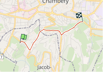

Length
2 km

Max alt
365 m

Uphill gradient
59 m
Km-Effort
2.8 km

Min alt
313 m

Downhill gradient
64 m
Boucle
No
Creation date :
2020-10-12 09:15:19.962
Updated on :
2020-10-12 16:57:37.834
3m
Difficulty : Very easy

FREE GPS app for hiking
 SityTrail
IGN / Geographical institutes
SityTrail Plus
The world is yours!
About
Trail Walking of 2 km to be discovered at Auvergne-Rhône-Alpes, Savoy, Jacob-Bellecombette. This trail is proposed by papou73.
Positioning
Country:
France
Region :
Auvergne-Rhône-Alpes
Department/Province :
Savoy
Municipality :
Jacob-Bellecombette
Location:
Unknown
Start:(Dec)
Start:(UTM)
727095 ; 5048991 (31T) N.
Comments