


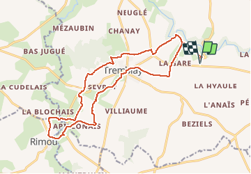
LA BEUCHERAIS-TREMBLAY-RIMOU-ET RETOUR-JY

COGLAIS3
User

Length
19.4 km

Max alt
108 m

Uphill gradient
271 m
Km-Effort
23 km

Min alt
12 m

Downhill gradient
271 m
Boucle
Yes
Creation date :
2020-10-13 05:50:35.296
Updated on :
2020-10-13 19:32:22.064
3h28
Difficulty : Easy

FREE GPS app for hiking
 SityTrail
IGN / Geographical institutes
SityTrail Plus
The world is yours!
About
Trail Nordic walking of 19.4 km to be discovered at Brittany, Ille-et-Vilaine, Val-Couesnon. This trail is proposed by COGLAIS3.
Positioning
Country:
France
Region :
Brittany
Department/Province :
Ille-et-Vilaine
Municipality :
Val-Couesnon
Location:
Tremblay
Start:(Dec)
Start:(UTM)
615593 ; 5364674 (30U) N.
Comments