


16.3.14 Gerardmer -Ch.Francis

delm
User
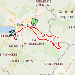

Length
10.6 km

Max alt
1042 m

Uphill gradient
486 m
Km-Effort
16.8 km

Min alt
667 m

Downhill gradient
376 m
Boucle
No
Creation date :
2014-12-10 00:00:00.0
Updated on :
2014-12-10 00:00:00.0
3h32
Difficulty : Unknown

FREE GPS app for hiking
 SityTrail
IGN / Geographical institutes
SityTrail Plus
The world is yours!
About
Trail Walking of 10.6 km to be discovered at Grand Est, Vosges, Gérardmer. This trail is proposed by delm.
Positioning
Country:
France
Region :
Grand Est
Department/Province :
Vosges
Municipality :
Gérardmer
Location:
Unknown
Start:(Dec)
Start:(UTM)
342384 ; 5326270 (32U) N.
Comments