


Montchenu

alinetpierre
User
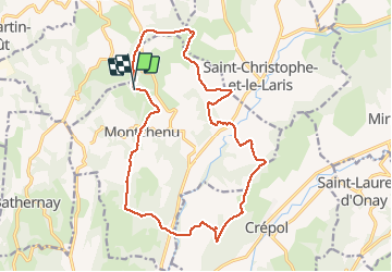

Length
18.5 km

Max alt
498 m

Uphill gradient
468 m
Km-Effort
25 km

Min alt
274 m

Downhill gradient
477 m
Boucle
Yes
Creation date :
2020-10-13 08:00:00.0
Updated on :
2020-10-13 12:06:34.129
3h37
Difficulty : Medium

FREE GPS app for hiking
 SityTrail
IGN / Geographical institutes
SityTrail Plus
The world is yours!
About
Trail Walking of 18.5 km to be discovered at Auvergne-Rhône-Alpes, Drôme, Montchenu. This trail is proposed by alinetpierre.
Description
Beaux paysages sur la Drome des collines
Positioning
Country:
France
Region :
Auvergne-Rhône-Alpes
Department/Province :
Drôme
Municipality :
Montchenu
Location:
Unknown
Start:(Dec)
Start:(UTM)
659358 ; 5007730 (31T) N.
Comments