


Promenade sous les nuages

fxhedon
User
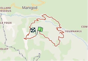

Length
10.2 km

Max alt
1246 m

Uphill gradient
479 m
Km-Effort
16.6 km

Min alt
846 m

Downhill gradient
483 m
Boucle
Yes
Creation date :
2020-10-15 10:16:32.0
Updated on :
2020-10-15 14:20:04.823
3h35
Difficulty : Unknown

FREE GPS app for hiking
 SityTrail
IGN / Geographical institutes
SityTrail Plus
The world is yours!
About
Trail Walking of 10.2 km to be discovered at Auvergne-Rhône-Alpes, Upper Savoy, Manigod. This trail is proposed by fxhedon.
Positioning
Country:
France
Region :
Auvergne-Rhône-Alpes
Department/Province :
Upper Savoy
Municipality :
Manigod
Location:
Unknown
Start:(Dec)
Start:(UTM)
296178 ; 5080461 (32T) N.
Comments