


Boucle l'endaydé en Nauzel Estebejon

tabouelle
User
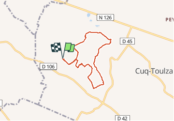

Length
6.6 km

Max alt
271 m

Uphill gradient
156 m
Km-Effort
8.7 km

Min alt
192 m

Downhill gradient
156 m
Boucle
Yes
Creation date :
2020-10-16 08:26:43.575
Updated on :
2020-10-16 10:51:22.629
2h23
Difficulty : Easy

FREE GPS app for hiking
 SityTrail
IGN / Geographical institutes
SityTrail Plus
The world is yours!
About
Trail Walking of 6.6 km to be discovered at Occitania, Tarn, Cuq-Toulza. This trail is proposed by tabouelle.
Photos


Positioning
Country:
France
Region :
Occitania
Department/Province :
Tarn
Municipality :
Cuq-Toulza
Location:
Unknown
Start:(Dec)
Start:(UTM)
407877 ; 4823784 (31T) N.
Comments