


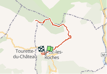
Mont Vial à partir de Revest les Roches

franquen
User

Length
9.9 km

Max alt
1530 m

Uphill gradient
679 m
Km-Effort
18.9 km

Min alt
853 m

Downhill gradient
678 m
Boucle
Yes
Creation date :
2020-10-16 09:25:44.906
Updated on :
2020-10-16 15:28:14.679
4h13
Difficulty : Medium

FREE GPS app for hiking
 SityTrail
IGN / Geographical institutes
SityTrail Plus
The world is yours!
About
Trail Walking of 9.9 km to be discovered at Provence-Alpes-Côte d'Azur, Maritime Alps, Revest-les-Roches. This trail is proposed by franquen.
Description
Bel itinéraire, sentier dans zone escarpée. petit détour à faire pour voir la grotte. Vue à 360° en haut
Positioning
Country:
France
Region :
Provence-Alpes-Côte d'Azur
Department/Province :
Maritime Alps
Municipality :
Revest-les-Roches
Location:
Unknown
Start:(Dec)
Start:(UTM)
351787 ; 4860404 (32T) N.
Comments