


col vert villard

brandy
User
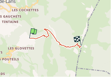

Length
3.7 km

Max alt
1746 m

Uphill gradient
546 m
Km-Effort
9.3 km

Min alt
1233 m

Downhill gradient
45 m
Boucle
No
Creation date :
2020-10-17 20:38:27.824
Updated on :
2020-10-17 20:39:02.954
--
Difficulty : Easy

FREE GPS app for hiking
 SityTrail
IGN / Geographical institutes
SityTrail Plus
The world is yours!
About
Trail On foot of 3.7 km to be discovered at Auvergne-Rhône-Alpes, Isère, Villard-de-Lans. This trail is proposed by brandy.
Description
rando
Positioning
Country:
France
Region :
Auvergne-Rhône-Alpes
Department/Province :
Isère
Municipality :
Villard-de-Lans
Location:
Unknown
Start:(Dec)
Start:(UTM)
702212 ; 4992368 (31T) N.
Comments