Trail Walking Anterrieux - Anterrieux - Photo
 neitag61
neitag61

User

© OpenStreetMap contributors
Length
Length
9 km
Max alt
Max alt
1059 m
Uphill gradient
Uphill gradient
221 m
Km-Effort
Km-Effort  
11.9 km
Min alt
Min alt
913 m
Downhill gradient
Downhill gradient
220 m
Boucle
Boucle
Yes
Creation date :
2020-10-18 09:23:40.789
Updated on :
2020-10-19 15:11:07.884

(0 Reviews)

Walking
Walking
2h32
Difficulty : Medium

Scan this QR Code to open this trail in the SityTrail application

FREE GPS app for hiking

Logo SityTrail SityTrail

IGN / Geographical institutes

Download SityTrail from the App Store Download SityTrail from Google Play

Logo SityTrail SityTrail World

The world is yours!

Download SityTrail from the App Store Download SityTrail from Google Play Download SityTrail on Huawei AppGallery

About

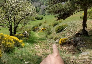
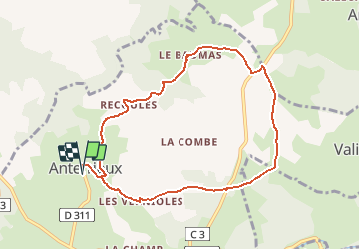
Trail Walking of 9 km to be discovered at Auvergne-Rhône-Alpes, Cantal, Anterrieux. This trail is proposed by neitag61.

Description

Joli circuit au milieu des herbages mais pas de traversée de champ avec troupeaux

Elevation profile

Positioning

Country:
France
Region :
Auvergne-Rhône-Alpes
Department/Province :
Cantal
Municipality :
Anterrieux
Location:
Unknown
Start:(UTM)
503472 ; 4964696 (31T) N.

Trails nearby

Trail On foot Chauchailles - 2022-05-31_19h34m27_gpx-trace - Photo
On foot
audier

On foot

Difficult
(1)
Chauchailles, Occitania, Lozère, France
22 km | 31 km-effort
7h 7min
Yes
Trail Walking Maurines - LES GORGES DU BES - Photo
Walking
Phil36

Walking

Medium
(1)
Maurines, Auvergne-Rhône-Alpes, Cantal, France
6.5 km | 9.2 km-effort
2h 5min
Yes
Trail Walking Chauchailles - sentier des espagnols  - Photo
Walking
GUIDE
nadinebondoux

Walking

Difficult
Chauchailles, Occitania, Lozère, France
22 km | 32 km-effort
6h 48min
Yes
Trail Walking Chauchailles - Gorges du Bèz sentier des espagnols - Photo
Walking
GUIDE
Roger Philippe Wallez

Walking

Very difficult
Chauchailles, Occitania, Lozère, France
22 km | 31 km-effort
7h 34min
Yes
Trail Walking Chaudes-Aigues - Chemin de la mine  - Photo
Walking
nicolasdresse

Walking

(1)
Chaudes-Aigues, Auvergne-Rhône-Alpes, Cantal, France
4.3 km | 6.1 km-effort
2h 11min
Yes
Trail Walking Chaudes-Aigues - La croix de Prunières - Chaudes Aigues - Photo
Walking
tracegps

Walking

Medium
(2)
Chaudes-Aigues, Auvergne-Rhône-Alpes, Cantal, France
14.8 km | 22 km-effort
3h 49min
No
Trail Walking Chauchailles - Les Gorges du Bes - Photo
Walking
tracegps

Walking

Difficult
(1)
Chauchailles, Occitania, Lozère, France
21 km | 30 km-effort
7h 0min
Yes
Trail Walking Maurines - le bez,départ de Morsange  - Photo
Walking
GILOU440

Walking

Medium
Maurines, Auvergne-Rhône-Alpes, Cantal, France
6.6 km | 9.3 km-effort
2h 45min
Yes
Trail Walking Saint-Juéry - Le Bes - Photo
Walking
viam19

Walking

Difficult
Saint-Juéry, Occitania, Lozère, France
15.3 km | 21 km-effort
7h 20min
Yes


Close
My subscriptions