


isier corrige1

ochelen
User
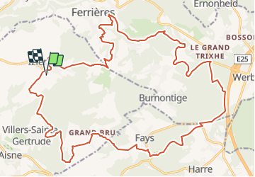

Length
28 km

Max alt
454 m

Uphill gradient
722 m
Km-Effort
38 km

Min alt
212 m

Downhill gradient
725 m
Boucle
Yes
Creation date :
2014-12-10 00:00:00.0
Updated on :
2014-12-10 00:00:00.0
1h40
Difficulty : Unknown

FREE GPS app for hiking
 SityTrail
IGN / Geographical institutes
SityTrail Plus
The world is yours!
About
Trail Other activity of 28 km to be discovered at Wallonia, Luxembourg, Durbuy. This trail is proposed by ochelen.


Positioning
Country:
Belgium
Region :
Wallonia
Department/Province :
Luxembourg
Municipality :
Durbuy
Location:
Izier
Start:(Dec)
Start:(UTM)
683704 ; 5584121 (31U) N.
Comments