


SityTrail - 2580949 - fourneville-

Laurent53
User
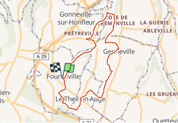

Length
16.4 km

Max alt
141 m

Uphill gradient
260 m
Km-Effort
19.9 km

Min alt
30 m

Downhill gradient
261 m
Boucle
Yes
Creation date :
2020-10-21 08:06:44.828
Updated on :
2020-10-21 08:16:48.486
--
Difficulty : Medium

FREE GPS app for hiking
 SityTrail
IGN / Geographical institutes
SityTrail Plus
The world is yours!
About
Trail On foot of 16.4 km to be discovered at Normandy, Calvados, Fourneville. This trail is proposed by Laurent53.
Positioning
Country:
France
Region :
Normandy
Department/Province :
Calvados
Municipality :
Fourneville
Location:
Unknown
Start:(Dec)
Start:(UTM)
299252 ; 5470804 (31U) N.
Comments