


Bidon Boucle Fontlongue

brandy
User
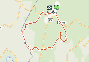

Length
9.5 km

Max alt
312 m

Uphill gradient
88 m
Km-Effort
10.7 km

Min alt
261 m

Downhill gradient
84 m
Boucle
Yes
Creation date :
2020-10-21 08:08:14.163
Updated on :
2020-10-21 08:09:03.615
2h22
Difficulty : Medium

FREE GPS app for hiking
 SityTrail
IGN / Geographical institutes
SityTrail Plus
The world is yours!
About
Trail Walking of 9.5 km to be discovered at Auvergne-Rhône-Alpes, Ardèche, Bidon. This trail is proposed by brandy.
Description
bonne chaussures !!!!
Positioning
Country:
France
Region :
Auvergne-Rhône-Alpes
Department/Province :
Ardèche
Municipality :
Bidon
Location:
Unknown
Start:(Dec)
Start:(UTM)
622330 ; 4913683 (31T) N.
Comments