


lamelouze

GOIOLIRIBES
User
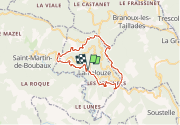

Length
16.3 km

Max alt
719 m

Uphill gradient
568 m
Km-Effort
24 km

Min alt
376 m

Downhill gradient
556 m
Boucle
Yes
Creation date :
2020-10-15 07:59:01.852
Updated on :
2020-10-21 13:15:54.369
6h33
Difficulty : Very easy

FREE GPS app for hiking
 SityTrail
IGN / Geographical institutes
SityTrail Plus
The world is yours!
About
Trail Walking of 16.3 km to be discovered at Occitania, Gard, Lamelouze. This trail is proposed by GOIOLIRIBES.
Positioning
Country:
France
Region :
Occitania
Department/Province :
Gard
Municipality :
Lamelouze
Location:
Unknown
Start:(Dec)
Start:(UTM)
576808 ; 4894022 (31T) N.
Comments