Auribeau. Mourre-Nègre

janussity
User
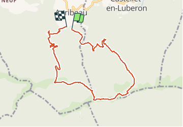

Length
9.5 km

Max alt
1122 m

Uphill gradient
576 m
Km-Effort
17.2 km

Min alt
595 m

Downhill gradient
585 m
Boucle
Yes
Creation date :
2020-10-21 07:29:55.497
Updated on :
2020-10-21 13:45:38.72
3h40
Difficulty : Difficult

FREE GPS app for hiking
 SityTrail
IGN / Geographical institutes
SityTrail Plus
The world is yours!
About
Trail Walking of 9.5 km to be discovered at Provence-Alpes-Côte d'Azur, Vaucluse, Auribeau. This trail is proposed by janussity.
Description
Difficultés techniques.
Rampes-Cailloux
Venteux
Photos


23 photos in total. Please click on a photo to see them all in the gallery.
Positioning
Country:
France
Region :
Provence-Alpes-Côte d'Azur
Department/Province :
Vaucluse
Municipality :
Auribeau
Location:
Unknown
Start:(Dec)
Start:(UTM)
697741 ; 4856203 (31T) N.
Comments