


21.10.2029 - pfaffenlap

delm
User
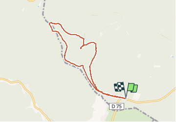

Length
7.4 km

Max alt
669 m

Uphill gradient
355 m
Km-Effort
12.1 km

Min alt
328 m

Downhill gradient
355 m
Boucle
Yes
Creation date :
2020-10-21 13:00:48.0
Updated on :
2020-10-21 15:30:31.238
2h29
Difficulty : Difficult

FREE GPS app for hiking
 SityTrail
IGN / Geographical institutes
SityTrail Plus
The world is yours!
About
Trail Walking of 7.4 km to be discovered at Grand Est, Bas-Rhin, Still. This trail is proposed by delm.
Positioning
Country:
France
Region :
Grand Est
Department/Province :
Bas-Rhin
Municipality :
Still
Location:
Unknown
Start:(Dec)
Start:(UTM)
377561 ; 5380010 (32U) N.
Comments