


Saint Gengoux le National les chaumes page 60

grasgilbert
User
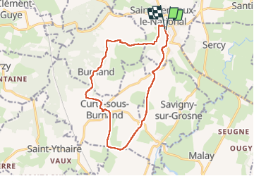

Length
14.1 km

Max alt
324 m

Uphill gradient
333 m
Km-Effort
18.6 km

Min alt
204 m

Downhill gradient
335 m
Boucle
Yes
Creation date :
2020-10-22 11:40:06.639
Updated on :
2022-10-24 11:58:07.998
3h35
Difficulty : Easy

FREE GPS app for hiking
 SityTrail
IGN / Geographical institutes
SityTrail Plus
The world is yours!
About
Trail Walking of 14.1 km to be discovered at Bourgogne-Franche-Comté, Saône-et-Loire, Saint-Gengoux-le-National. This trail is proposed by grasgilbert.
Positioning
Country:
France
Region :
Bourgogne-Franche-Comté
Department/Province :
Saône-et-Loire
Municipality :
Saint-Gengoux-le-National
Location:
Unknown
Start:(Dec)
Start:(UTM)
627429 ; 5163048 (31T) N.
Comments
bien