


Puissalicon - Saint-Pierre de Serjac - Cazilhac - Coulobres- Puech Ginestieu

PiloudeBamako
User
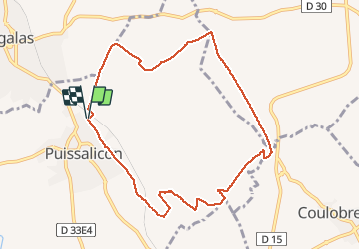

Length
9.5 km

Max alt
133 m

Uphill gradient
116 m
Km-Effort
11 km

Min alt
70 m

Downhill gradient
115 m
Boucle
Yes
Creation date :
2020-10-24 08:44:48.0
Updated on :
2020-10-24 16:09:34.182
1h15
Difficulty : Medium

FREE GPS app for hiking
 SityTrail
IGN / Geographical institutes
SityTrail Plus
The world is yours!
About
Trail Running of 9.5 km to be discovered at Occitania, Hérault, Puissalicon. This trail is proposed by PiloudeBamako.
Description
Circuit en bouche dans les vignes.
Photos

Positioning
Country:
France
Region :
Occitania
Department/Province :
Hérault
Municipality :
Puissalicon
Location:
Unknown
Start:(Dec)
Start:(UTM)
519140 ; 4812182 (31T) N.
Comments