


Sortie beaujolais 2510

jpfrobert
User
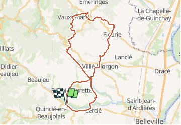

Length
35 km

Max alt
545 m

Uphill gradient
645 m
Km-Effort
44 km

Min alt
217 m

Downhill gradient
647 m
Boucle
Yes
Creation date :
2020-10-25 10:56:09.675
Updated on :
2020-10-25 10:57:19.593
2h00
Difficulty : Very easy

FREE GPS app for hiking
 SityTrail
IGN / Geographical institutes
SityTrail Plus
The world is yours!
About
Trail Bicycle tourism of 35 km to be discovered at Auvergne-Rhône-Alpes, Rhône, Régnié-Durette. This trail is proposed by jpfrobert.
Positioning
Country:
France
Region :
Auvergne-Rhône-Alpes
Department/Province :
Rhône
Municipality :
Régnié-Durette
Location:
Unknown
Start:(Dec)
Start:(UTM)
626329 ; 5109255 (31T) N.
Comments