


pierre bazanne et roche gourgon

eoriol
User
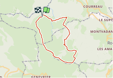

Length
14.8 km

Max alt
1413 m

Uphill gradient
297 m
Km-Effort
18.7 km

Min alt
1258 m

Downhill gradient
300 m
Boucle
Yes
Creation date :
2020-10-28 08:59:15.685
Updated on :
2020-10-28 12:27:22.168
3h20
Difficulty : Easy

FREE GPS app for hiking
 SityTrail
IGN / Geographical institutes
SityTrail Plus
The world is yours!
About
Trail Walking of 14.8 km to be discovered at Auvergne-Rhône-Alpes, Loire, Saint-Bonnet-le-Courreau. This trail is proposed by eoriol.
Positioning
Country:
France
Region :
Auvergne-Rhône-Alpes
Department/Province :
Loire
Municipality :
Saint-Bonnet-le-Courreau
Location:
Unknown
Start:(Dec)
Start:(UTM)
567656 ; 5053830 (31T) N.
Comments