


villers

Claude Luchetta
User
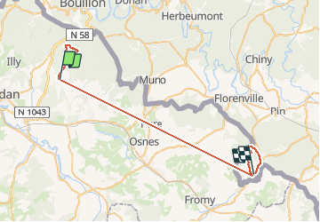

Length
43 km

Max alt
410 m

Uphill gradient
982 m
Km-Effort
56 km

Min alt
183 m

Downhill gradient
994 m
Boucle
No
Creation date :
2020-10-20 11:58:54.826
Updated on :
2020-10-28 14:45:37.307
4h32
Difficulty : Very easy

FREE GPS app for hiking
 SityTrail
IGN / Geographical institutes
SityTrail Plus
The world is yours!
About
Trail Walking of 43 km to be discovered at Grand Est, Ardennes, Bazeilles. This trail is proposed by Claude Luchetta.
Positioning
Country:
France
Region :
Grand Est
Department/Province :
Ardennes
Municipality :
Bazeilles
Location:
Unknown
Start:(Dec)
Start:(UTM)
646501 ; 5509157 (31U) N.
Comments