


burie

Arnaud Dejean
User
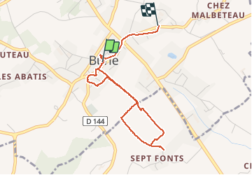

Length
4 km

Max alt
65 m

Uphill gradient
36 m
Km-Effort
4.5 km

Min alt
47 m

Downhill gradient
29 m
Boucle
No
Creation date :
2020-10-28 14:40:02.104
Updated on :
2020-10-28 18:42:02.253
57m
Difficulty : Very easy

FREE GPS app for hiking
 SityTrail
IGN / Geographical institutes
SityTrail Plus
The world is yours!
About
Trail Walking of 4 km to be discovered at New Aquitaine, Charente-Maritime, Burie. This trail is proposed by Arnaud Dejean.
Positioning
Country:
France
Region :
New Aquitaine
Department/Province :
Charente-Maritime
Municipality :
Burie
Location:
Unknown
Start:(Dec)
Start:(UTM)
700489 ; 5072148 (30T) N.
Comments