


col des charcon

panetJeanLuc
User
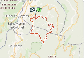

Length
14.4 km

Max alt
1311 m

Uphill gradient
765 m
Km-Effort
25 km

Min alt
587 m

Downhill gradient
773 m
Boucle
Yes
Creation date :
2020-10-29 08:13:29.458
Updated on :
2020-10-29 15:29:44.69
7h11
Difficulty : Very easy

FREE GPS app for hiking
 SityTrail
IGN / Geographical institutes
SityTrail Plus
The world is yours!
About
Trail Walking of 14.4 km to be discovered at Auvergne-Rhône-Alpes, Drôme, Saint-Jean-en-Royans. This trail is proposed by panetJeanLuc.
Description
belle randonnée avec de
Positioning
Country:
France
Region :
Auvergne-Rhône-Alpes
Department/Province :
Drôme
Municipality :
Saint-Jean-en-Royans
Location:
Unknown
Start:(Dec)
Start:(UTM)
681386 ; 4985269 (31T) N.
Comments