


aze

Nila81
User
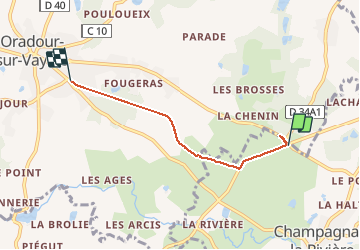

Length
3.8 km

Max alt
368 m

Uphill gradient
52 m
Km-Effort
4.5 km

Min alt
327 m

Downhill gradient
60 m
Boucle
No
Creation date :
2020-10-29 15:52:14.32
Updated on :
2020-10-29 16:40:02.881
47m
Difficulty : Very easy

FREE GPS app for hiking
 SityTrail
IGN / Geographical institutes
SityTrail Plus
The world is yours!
About
Trail Walking of 3.8 km to be discovered at New Aquitaine, Haute-Vienne, Champagnac-la-Rivière. This trail is proposed by Nila81.
Description
auradour
Positioning
Country:
France
Region :
New Aquitaine
Department/Province :
Haute-Vienne
Municipality :
Champagnac-la-Rivière
Location:
Unknown
Start:(Dec)
Start:(UTM)
337154 ; 5065262 (31T) N.
Comments