


Tienne des Pairées 2020

fra_depoorter
User


1h28
Difficulty : Very easy

FREE GPS app for hiking
 SityTrail
IGN / Geographical institutes
SityTrail Plus
The world is yours!
About
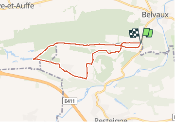
Trail Walking of 6.8 km to be discovered at Wallonia, Luxembourg, Tellin. This trail is proposed by fra_depoorter.
Description
Belle randonnée très facile depuis le parking (entre Belvaux et Resteigne) et la carrière des limites de Ave-et-Auffe/Wellin. Nombreuses possibilités pour allonger la balade soit vers Resteigne(Lesse) soit vers Auffe (bois de Niaux) soit vers Ave.
Positioning
Comments