


Mirwart 2020

fra_depoorter
User


3h04
Difficulty : Medium

FREE GPS app for hiking
 SityTrail
IGN / Geographical institutes
SityTrail Plus
The world is yours!
About
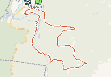
Trail Walking of 11.6 km to be discovered at Wallonia, Luxembourg, Saint-Hubert. This trail is proposed by fra_depoorter.
Description
Merveilleuse randonnée empruntée à Gérard Bouche. Après une rude montée, jolie descente vers la L'homme pour la suivre jusqu'aux étangs et l'ancien moulin. La remontée vers le château est assez hasardeuse par manque de repère sur le terrain.
Positioning
Comments
Merci à vous. Depuis la vallée mosane, je randonne souvent dans cette magnifique forêt de St-Hubert et Mirwart en particulier ! Le petit sentier qui nous remonte vers le Château à déjà été " interdit " aux randonneurs ... souhaitons, maintenant, que le nouveau propriétaire du Château nous accorde toujours et pour les jours à venir le droit de passage !