


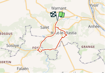
Molignee (Ht Le Wastia) Ruines Montaigle Ravel

thomarche
User

Length
9.2 km

Max alt
220 m

Uphill gradient
213 m
Km-Effort
12.1 km

Min alt
109 m

Downhill gradient
213 m
Boucle
Yes
Creation date :
2020-11-08 11:58:56.0
Updated on :
2020-11-08 14:44:22.716
2h44
Difficulty : Unknown

FREE GPS app for hiking
 SityTrail
IGN / Geographical institutes
SityTrail Plus
The world is yours!
About
Trail Walking of 9.2 km to be discovered at Wallonia, Namur, Anhée. This trail is proposed by thomarche.
Positioning
Country:
Belgium
Region :
Wallonia
Department/Province :
Namur
Municipality :
Anhée
Location:
Warnant
Start:(Dec)
Start:(UTM)
630621 ; 5575160 (31U) N.
Comments