


La Durance depuis St Clément

DaVinci
User
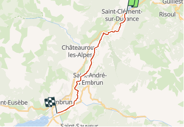

Length
15.6 km

Max alt
883 m

Uphill gradient
113 m
Km-Effort
17.4 km

Min alt
781 m

Downhill gradient
200 m
Boucle
No
Creation date :
2020-11-09 17:03:08.237
Updated on :
2020-11-09 17:36:55.429
3h00
Difficulty : Medium

FREE GPS app for hiking
 SityTrail
IGN / Geographical institutes
SityTrail Plus
The world is yours!
About
Trail Canoe - kayak of 15.6 km to be discovered at Provence-Alpes-Côte d'Azur, Hautes-Alpes, Saint-Clément-sur-Durance. This trail is proposed by DaVinci.
Positioning
Country:
France
Region :
Provence-Alpes-Côte d'Azur
Department/Province :
Hautes-Alpes
Municipality :
Saint-Clément-sur-Durance
Location:
Unknown
Start:(Dec)
Start:(UTM)
308360 ; 4946863 (32T) N.
Comments