


Mirwart 20 km

pierlan
User
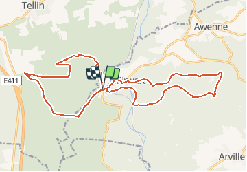

Length
21 km

Max alt
477 m

Uphill gradient
514 m
Km-Effort
27 km

Min alt
258 m

Downhill gradient
512 m
Boucle
Yes
Creation date :
2020-11-10 10:00:47.331
Updated on :
2020-11-11 07:50:21.631
4h10
Difficulty : Very easy

FREE GPS app for hiking
 SityTrail
IGN / Geographical institutes
SityTrail Plus
The world is yours!
About
Trail Trail of 21 km to be discovered at Wallonia, Luxembourg, Saint-Hubert. This trail is proposed by pierlan.
Positioning
Country:
Belgium
Region :
Wallonia
Department/Province :
Luxembourg
Municipality :
Saint-Hubert
Location:
Mirwart
Start:(Dec)
Start:(UTM)
661200 ; 5547094 (31U) N.
Comments