


RAC Durbuy

Chanchan63
User
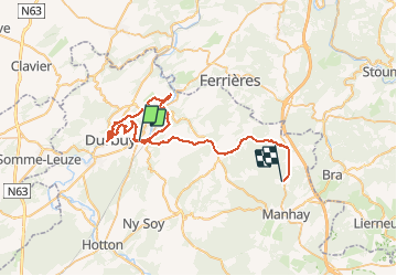

Length
47 km

Max alt
506 m

Uphill gradient
1174 m
Km-Effort
61 km

Min alt
130 m

Downhill gradient
813 m
Boucle
No
Creation date :
2020-11-08 09:54:25.893
Updated on :
2020-11-11 21:08:20.536
7h18
Difficulty : Easy

FREE GPS app for hiking
 SityTrail
IGN / Geographical institutes
SityTrail Plus
The world is yours!
About
Trail Walking of 47 km to be discovered at Wallonia, Luxembourg, Durbuy. This trail is proposed by Chanchan63.
Description
Pas top trop de tarmac
Photos


25 photos in total. Please click on a photo to see them all in the gallery.
Positioning
Country:
Belgium
Region :
Wallonia
Department/Province :
Luxembourg
Municipality :
Durbuy
Location:
Barvaux
Start:(Dec)
Start:(UTM)
677378 ; 5580644 (31U) N.
Comments