


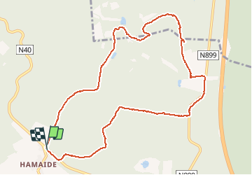
Redu Hamaide-Bestin 2020

fra_depoorter
User


2h14
Difficulty : Easy

FREE GPS app for hiking
 SityTrail
IGN / Geographical institutes
SityTrail Plus
The world is yours!
About
Trail Walking of 10.2 km to be discovered at Wallonia, Luxembourg, Libin. This trail is proposed by fra_depoorter.
Description
Jolie randonnée sur chemins larges et souvent empierrés. Belle drève de châtaigniers à proximité du Glan (rivière) qui forme des étangs à certains endroits.
Passage en "propriété privée - accès interdit". autour du château de Bestin..
Positioning
Comments
top.Dommage la propriété privée