


Sortie lalbenque 15km

cps46
User
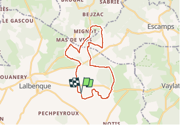

Length
15.5 km

Max alt
303 m

Uphill gradient
145 m
Km-Effort
17.5 km

Min alt
256 m

Downhill gradient
145 m
Boucle
Yes
Creation date :
2020-11-15 08:29:52.0
Updated on :
2020-11-15 10:25:25.112
1h56
Difficulty : Unknown

FREE GPS app for hiking
 SityTrail
IGN / Geographical institutes
SityTrail Plus
The world is yours!
About
Trail Running of 15.5 km to be discovered at Occitania, Lot, Lalbenque. This trail is proposed by cps46.
Positioning
Country:
France
Region :
Occitania
Department/Province :
Lot
Municipality :
Lalbenque
Location:
Unknown
Start:(Dec)
Start:(UTM)
386689 ; 4909887 (31T) N.
Comments