


HAUT MANIVAL-0

RD78-38
User
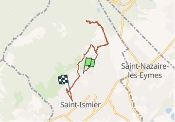

Length
7.1 km

Max alt
677 m

Uphill gradient
339 m
Km-Effort
11.6 km

Min alt
395 m

Downhill gradient
327 m
Boucle
No
Creation date :
2020-11-15 13:09:20.0
Updated on :
2020-11-15 15:28:03.495
1h42
Difficulty : Easy

FREE GPS app for hiking
 SityTrail
IGN / Geographical institutes
SityTrail Plus
The world is yours!
About
Trail Walking of 7.1 km to be discovered at Auvergne-Rhône-Alpes, Isère, Saint-Ismier. This trail is proposed by RD78-38.
Description
Premier repérage
Positioning
Country:
France
Region :
Auvergne-Rhône-Alpes
Department/Province :
Isère
Municipality :
Saint-Ismier
Location:
Unknown
Start:(Dec)
Start:(UTM)
721824 ; 5015262 (31T) N.
Comments