


Vercheny

raygautier
User
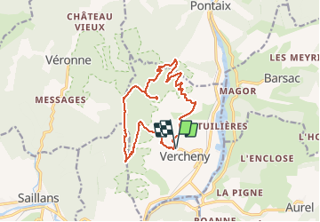

Length
15.3 km

Max alt
984 m

Uphill gradient
663 m
Km-Effort
24 km

Min alt
430 m

Downhill gradient
664 m
Boucle
Yes
Creation date :
2020-11-15 08:34:08.0
Updated on :
2020-11-18 06:19:58.645
6h56
Difficulty : Unknown

FREE GPS app for hiking
 SityTrail
IGN / Geographical institutes
SityTrail Plus
The world is yours!
About
Trail Walking of 15.3 km to be discovered at Auvergne-Rhône-Alpes, Drôme, Vercheny. This trail is proposed by raygautier.
Description
Difficile i koi
Positioning
Country:
France
Region :
Auvergne-Rhône-Alpes
Department/Province :
Drôme
Municipality :
Vercheny
Location:
Unknown
Start:(Dec)
Start:(UTM)
678278 ; 4953317 (31T) N.
Comments