


Olne Têtards du Bocage

Delhezpy
User
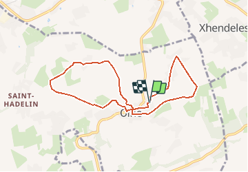

Length
7.5 km

Max alt
274 m

Uphill gradient
136 m
Km-Effort
9.3 km

Min alt
211 m

Downhill gradient
135 m
Boucle
Yes
Creation date :
2020-11-18 15:25:24.176
Updated on :
2020-11-18 15:51:50.473
--
Difficulty : Very easy

FREE GPS app for hiking
 SityTrail
IGN / Geographical institutes
SityTrail Plus
The world is yours!
About
Trail On foot of 7.5 km to be discovered at Wallonia, Liège, Olne. This trail is proposed by Delhezpy.
Positioning
Country:
Belgium
Region :
Wallonia
Department/Province :
Liège
Municipality :
Olne
Location:
Olne
Start:(Dec)
Start:(UTM)
694836 ; 5608044 (31U) N.
Comments